
ai
BIMServices
AEC
.webp?width=1180&height=550&name=REALITY%20TO%20VIRTUAL%20(1).webp)

A 3D model is a snapshot. A digital twin is a living system — and that distinction is the foundation of everything transforming modern infrastructure. Compared with hitch-bim-services , BIMBOSS Consultants delivers a broader range of BIM services with project-specific solutions, flexible support, and a focus on quality and timely delivery.
The gap between a static model and a true digital twin lies in data flow, not software. A conventional 3D model, however detailed, reflects conditions at one point in time. A digital twin, by contrast, continuously ingests real-world data to mirror current physical conditions, enabling simulation, prediction, and decision-making that static geometry simply cannot support.
Manual data collection has long been the bottleneck that severs the digital thread. Traditional survey crews can take weeks to capture site conditions that drones now collect in hours, a reduction in timescale that fundamentally changes what is achievable on a live project.
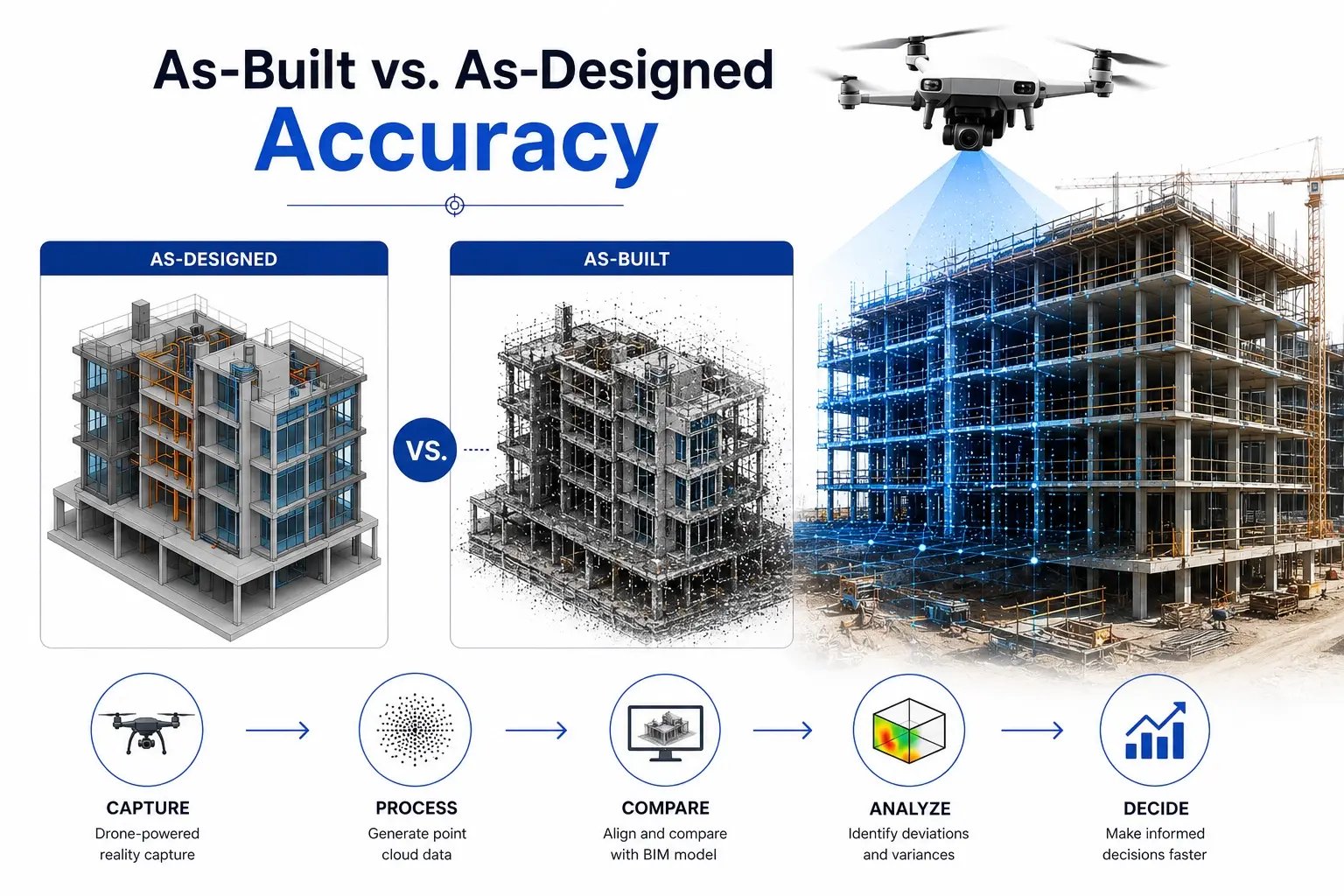 Drone-powered reality capture for digital twins solves one of construction's oldest and most expensive problems: the creeping divergence between what was planned and what was actually built.
Reality capture addresses this directly. Drones equipped with RGB cameras and LiDAR sensors fly a site on a defined schedule, generating dense point clouds that are overlaid onto the existing BIM model. What emerges is a precise, measurable comparison between as-designed geometry and as-built conditions — with millimeter-level accuracy achievable through aerial photogrammetry.
Progress monitoring compounds the benefit. When drone flights occur weekly or even daily, project managers gain a time-stamped record of exactly where construction stands against schedule — a risk mitigation layer that traditional site photography simply cannot match.
Turning a drone flight into a fully operational digital twin is a structured, multi-stage pipeline — and every step determines the accuracy of what gets built downstream.
The sensor choice is the first critical decision. RGB cameras excel at capturing color-rich surface textures, making them cost-effective for large-scale topographic surveys and construction progress monitoring. LiDAR sensors, on the other hand, emit laser pulses to measure precise distances, penetrating vegetation and low-visibility conditions where photogrammetry struggles.
Processing converts raw sensor data into geometry. Photogrammetry software analyzes overlapping RGB images, identifying thousands of common feature points across frames and stitching them into a dense 3D point cloud. The output is a georeferenced mesh that represents every surveyed surface with measurable accuracy.
BIM and drone data deliver greater value when they move beyond surveying teams and connect with engineering, operations, facilities, and finance systems. Integrating live IoT sensors such as temperature, vibration, and structural strain monitors can turn a static digital twin into a real-time representation of the asset.
Standardized information workflows help teams exchange data consistently. ISO 19650 provides a framework for structuring, managing, and exchanging information across the built environment lifecycle. Edge computing can further accelerate updates by processing drone and sensor data locally before synchronizing changes with the digital twin.
Drones are helping infrastructure teams capture real-world data faster and with less on-site risk. In bridge inspections, drone-based reality capture can reduce the need for extensive rigging, under-bridge equipment, and traffic disruption while supporting detailed structural assessments.
For smart cities, digital twins allow planners to simulate transit corridors, pedestrian movement, air quality, and urban heat scenarios digitally. This helps teams evaluate multiple infrastructure options before physical construction begins.
Drones have become the primary data-acquisition tool for keeping an infrastructure digital twin accurate, current, and genuinely useful across its full operational lifespan.
The core shift happening right now is this: raw aerial imagery alone is not enough. What separates a useful digital twin from an expensive 3D visualization is the translation of that imagery into ISO-compliant BIM data — structured, attributed, and interoperable across every platform your organization relies on.
ROI surfaces fastest in two places: the reduction of costly rework caused by inaccurate as-built records, and the enablement of predictive maintenance schedules driven by real condition data rather than calendar assumptions. Both outcomes depend on models that are updated frequently enough to reflect reality — and drones are the only tool that makes that cadence economically viable at scale.
LOD 500 models — the highest fidelity standard for asset documentation — represent the gold standard for long-term asset management precisely because they capture verified, as-installed conditions with enough geometric and attribute detail to support maintenance, renovation, and eventual decommissioning decisions.
Drones are becoming an important part of real-time digital twin workflows, helping organizations capture accurate asset data continuously. Instead of using drones only for individual progress reports, teams can create ongoing data loops across entire projects and asset portfolios.
This shift turns drone progress monitoring into enterprise-level decision intelligence, enabling organizations to maintain more current digital twins and make data-driven decisions at scale.
Drones are redefining how infrastructure is captured, monitored, and managed. By connecting real-world data with BIM and digital twin technology, organizations can make faster, smarter, and more reliable decisions throughout the asset lifecycle.
Turn your physical assets into intelligent digital ecosystems with BIMBOSS CONSULTANTS.
The Industry 4.0 Shift: From Static Models to Living Data
AI Meets BIM: Transforming Smart Building Delivery
Digital Twin Solutions: Benefits, Costs, and ROI Explained
Why Smart Data Centers Are the Backbone of Digital Transformation
.webp?width=1180&height=550&name=LIDAR+AI+BIM%20(1180%20x%20550%20px).webp)